More snow and ice coming to Maine before a big Spring preview

Nappi’s Notes 3.4.26

March is starting out snowy, but a big warm-up is coming early next week with a run for record highs in northern Maine. Most of the snowpack will be melted in the coming days, outside of the higher elevations and high into North Country.

There’s also more snow and some ice coming. First, there will be light snow in North Country tonight into tomorrow. Then moderate snow arrives Thursday night in southern Maine with some icing in York County.

Light freezing rain moves in Saturday morning through the day for nearly a statewide icy setup, but not a big ice storm at all.

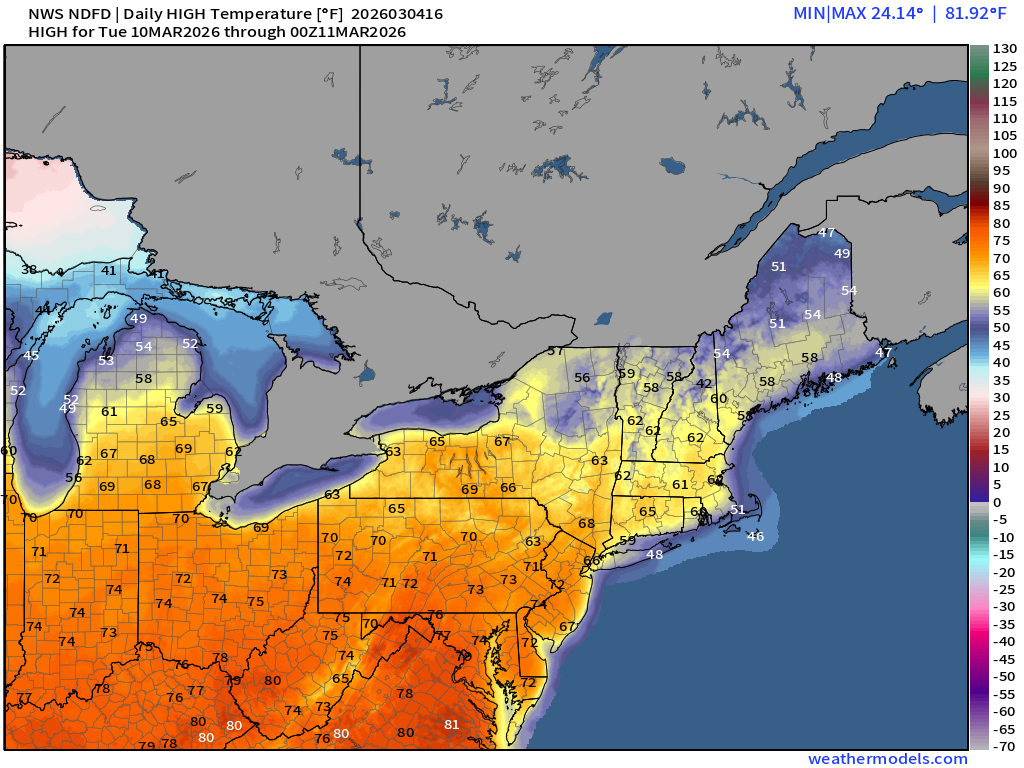
Temps get into the 50s by later Saturday and Sunday, then a run for the 60s on Monday and Tuesday. The models are showing 70s and that’s just hard to believe at this point.

It gets cold again late next week with an opportunity for snow in the forecast. Winter isn’t done.

Wednesday Maps

10 day

CARIBOU, ME BANGOR, ME PORTLAND, ME AUGUSTA, ME LEWISTON, ME KITTERY, ME

Here’s how I did with the last storm:

Latest storm reports for snow:

Map showing various locations in a coastal area with blue dots indicating specific points and numerical values associated with each location.

Compared to my forecast:

Weather forecast map showing snow accumulation expectations: heavy wet snow in some areas, with totals ranging from trace amounts to 5 inches. Includes time frame from Tuesday 1 PM to Wednesday 5 AM.

It will be mild today, but a back door cold arrives tomorrow into Friday, setting the stage for more wintry weather.

Weather map showing maximum 6-hourly 2-meter temperatures in degrees Fahrenheit for the northeastern United States, with color gradient representing different temperature ranges.

Once that cold air is in place a storm approaches from the south.

Weather map showing precipitation types and reflectivity levels across the northeastern United States for March 4-6, 2026, with varying colors indicating rain, snow, freezing rain, and sleet.
Weather map showing precipitation types and reflectivity for the northeastern United States, with rain, snow, and mixed precipitation indicated by color coding.

It will be snow for most of southern Maine with some icing, too.

Snow forecast for late Thu into Fri.

Map showing expected snowfall forecasts for March 4-7, 2026, across northern and northeastern regions of the United States, with color-coded snowfall amounts ranging from 0.5 inches to over 12 inches.

Things briefly dry out Friday night with a light bit of precip coming for Friday night into Saturday.

The freezing rain will be light, but still can make thing slippery on Saturday morning especially.

Weather radar map showing reflectivity and precipitation types for the northeastern United States on March 7, 2026, indicating areas of rain, snow, and freezing rain.

Temps warm up this weekend, but will be held in check somewhat. The models think Maine sees 70s next week and I am skeptical at this point.

Weather map displaying maximum 6-hourly temperature predictions in degrees Fahrenheit for the eastern United States on March 4, 2026. The color gradient shows varying temperatures, from cooler tones in the north to warmer tones in the south.

It’s more reasonable to believe 50s and 60s are coming Monday and Tuesday.

Weather map showing daily high temperatures across the U.S. for March 10, 2026, with varying temperature zones highlighted in different colors, ranging from cold in the north to warmer temperatures in the south.

The ridge of high pressure will pump in the warm temps, but Old Man Winter returns later next week with more troughs and cold air.

Weather map showing 500 hPa geopotential height and anomalies across the United States for March 2026, with color gradients representing height variations.

The opportunity for snow is back by the middle of the month. So while the snowpack goes away early next week, it can and will likely come back for Maine.

Map showing projected snow depth in inches for the northeastern United States, with varying colors indicating different levels of accumulation.

More details coming soon.

Thank You,
Jason

Leave a Reply

Accurate, Relatable, Straightforward Weather

Discover more from Jason Nappi Weather

Subscribe now to keep reading and get access to the full archive.

Continue reading